
Topographic Survey Information Needed to Redevelop Vacant Urban Parcels
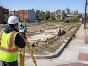
A vacant lot in an urban setting rarely means an empty, blank piece of ground. Old foundations, buried debris, and altered grades from a building that once stood there often remain, even years after demolition. A topographic survey records all of this, giving a redevelopment project an honest picture of the site rather than treating it as a fresh start with no history at all.
Skipping this step and assuming the parcel is genuinely clean tends to cause problems once design work begins, when hidden site conditions turn out to conflict with the assumptions built into the plan.
Recording the Ground Left Behind After Earlier Structures
Demolition rarely removes every trace of what came before. Slabs, foundation remnants, uneven fill, and shifted grades are common on urban lots where a building once stood, and each of these leftover features can affect how new construction gets planned.
Recording these conditions accurately gives the design team a realistic starting point. A grading plan built without accounting for buried debris or uneven fill risks running into unexpected obstacles once excavation actually begins on the site.
Measuring Street, Curb, and Sidewalk Elevations
A vacant parcel does not exist in isolation from the public infrastructure around it. Street, curb, and sidewalk elevations along the property frontage shape how a new building will connect to the surrounding neighborhood, and these measurements need to be recorded as part of the survey.
This relationship matters for both design and drainage. A new building set at the wrong elevation relative to the street can create awkward entry conditions or interfere with how water moves along the public right of way, problems that are far easier to avoid than to fix later.
Locating Utility Evidence at the Site Edges
Manholes, valves, poles, and meters along the edges of a vacant parcel offer visible clues about what utility infrastructure serves, or could serve, the property. Recording the location of these features helps a design team understand what connections are realistically available.
This visible evidence does not tell the whole story on its own, since underground lines are not always marked clearly at the surface. Combining what can be seen with available utility records gives a more complete picture of the infrastructure surrounding the site.
Identifying Water Collection Points Within the Lot
Even a small vacant lot can have low spots where water collects after a rain, and these points need to be identified before any grading or foundation planning moves forward. A depression that goes unnoticed during the survey can turn into a real drainage problem once construction begins.
Mapping these collection points alongside the rest of the terrain data gives the design team the information needed to plan grading that actually resolves existing drainage issues, rather than building around them and hoping for the best.
Building a Reliable Existing-Conditions Drawing for Designers
Every piece of information gathered during the survey eventually comes together in one existing conditions drawing, and this document becomes the foundation for the civil, architectural, and landscape work that follows. A reliable base map here saves time across every discipline working on the project.
Designers working from accurate existing conditions data can move through their work with real confidence, rather than pausing repeatedly to verify assumptions about the site. This efficiency is one of the clearest practical benefits of a thorough topographic survey on a redevelopment project.
Frequently Asked Questions
Does a vacant parcel still need detailed surveying?
Yes. The absence of a building does not remove terrain, boundary, utility, or drainage concerns that still need to be understood before building.
Can buried foundations be shown?
Only when they are visible, detected through separate methods, or supported by reliable information included within the agreed survey scope.
Will the Topographic Survey include adjoining buildings?
Nearby features may be included when they are relevant to the design work and requested as part of the survey coverage.
For a free land surveying quote, call us at (410) 883-5300 or send us a message by going here.
Posted in Topographic Survey