
Surveying the Footprints of Buildings That No Longer Exist
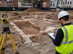
The footprints of buildings that no longer exist can still matter years after the walls come down. A demolished structure leaves questions behind, about old shared walls, past uses and where things once stood. Surveying those former building footprints helps a new project understand the site it inherits. The work blends old records with physical clues to place a vanished building back on the map.
Why Former Building Locations Still Matter
A building can be gone while its influence lingers. Demolition and redevelopment raise questions about zoning history, past environmental use and old legal descriptions that referenced the structure. Answering them often starts with knowing exactly where the building sat.
Shared walls and access add more reasons. A former building may have shared a wall with its neighbor, or provided an access route that a deed still mentions. Placing the old footprint clears up how those arrangements worked.
Site planning benefits too. A designer laying out new work wants to know what stood there before and where its foundations lie. The old footprint informs how the fresh project fits the ground.
Finding Reliable Records of the Removed Structure
The search begins in the archives. Historic surveys, fire-insurance maps, building permits and demolition plans all record where a structure stood. Each source offers a different view of the same lost building.
Aerial photographs and utility records fill in more. An old aerial can show the building’s outline against the surrounding lot, while utility records hint at where services entered it. Architectural drawings, when they survive, add fine detail.
No single record settles it alone. The surveyor reads them together, weighing how accurate and how current each one is. A permit and an aerial that agree carry more weight than either by itself.
Recognizing Physical Traces Remaining on the Site
The ground itself often remembers a building. Foundation remnants, pavement seams and scars on a neighboring wall all mark where a structure once stood, and a trained eye reads these traces during fieldwork. Utility stubs, grade changes and shifts in paving material can trace an old footprint’s edge.
These physical traces check the records. When a foundation remnant lines up with an old fire map, confidence grows, and when they disagree, the surveyor digs deeper before drawing a conclusion. What looks like random ground to most people tells a story to a surveyor.
Georeferencing Historic Information to Current Survey Control
An old map means little until it lands on modern coordinates. Georeferencing ties historic information to the site’s current control by matching common points that appear in both. A surviving corner or street line can serve as that link.
Old records resist a clean fit. Scale limitations and distortion mean an old map can’t simply be laid over a modern survey without care. The surveyor stretches and rotates the historic data thoughtfully, checking it against known points.
This step demands honesty about limits. A century-old drawing will never match modern accuracy perfectly. The surveyor fits it as well as the evidence allows and notes where the fit stays loose.
Classifying the Confidence of a Reconstructed Footprint
Not every part of a reconstructed footprint deserves equal trust, so the surveyor grades it. Some edges rest on solid evidence, while others rely on a single faded clue. Marking that difference keeps users from overtrusting the result.
A simple scale helps. A line might be confirmed by strong evidence, inferred from partial clues, approximate where sources conflict or undocumented where nothing survives. Each label tells the reader how much weight to give that edge.
This honesty is the real value of the work. A footprint that admits its uncertain parts serves a project better than one that pretends to false precision. The confidence grading lets a design team plan around what is truly known.
For a free land surveying quote, call us at (410) 883-5300 or send us a message by going here.
Posted in land surveying, land surveyor
