
Selective Rowhouse Demolition Needs Construction Survey Monitoring Next Door
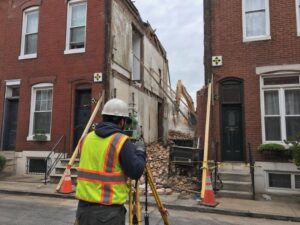
Construction survey monitoring protects the buildings that stay when a rowhouse in the middle of a block comes down. Rowhouses share walls, and that changes everything about a demolition. Taking one down means working inches from homes that people still live in, against walls that may have leaned on each other for a hundred years. A survey crew watches those neighboring structures throughout the work, measuring whether they hold steady or start to move. That record is what keeps a routine demolition from becoming a disaster next door.
Establishing Reference Points on Adjacent Buildings
The monitoring starts before demolition, with a set of fixed points on the buildings that will remain. Crews install small, permanent targets on the adjacent facades, party walls and any structural feature worth watching. Each point gets a precise position and elevation recorded as a baseline.
Baseline readings define normal. Every measurement afterward gets compared against this starting set, so the quality of the baseline determines the quality of the whole program. Crews measure carefully and repeatedly at the start, since a sloppy baseline hides real movement or invents movement that isn’t there.
Point selection follows the risk. Crews place targets where movement would show first and matter most, such as the top of a party wall, the corners of the adjacent buildings, and any spot already showing cracks. A good layout captures the building’s behavior without cluttering it with points that tell you nothing.
Recording Existing Wall Position and Condition
Documentation of the starting condition protects everyone. Before anything comes down, crews record the position of the party walls, the neighboring facades and the roofs where they can reach them. They note existing cracks, leans, bulges and any damage that predates the work.
That record settles disputes before they happen. A neighbor who claims the demolition cracked their wall gets compared against a documented baseline showing the crack was already there. Without that documentation, every pre-existing flaw becomes an argument.
Photographs support the measurements. Crews photograph the walls, the cracks and the overall condition, tying each image to a mapped location. Combined with the measured positions, that gives a complete picture of how the neighboring buildings stood on day one.
Tracking Movement During High-Risk Demolition Stages
Some stages of demolition carry far more risk than others, and monitoring intensifies during them. When a party wall gets exposed, when a shared foundation loses the support of the building next door, or when heavy equipment works close to the line, crews measure more often.
Repeat readings reveal trends. A single measurement means little, but a series showing a wall moving a small amount each day tells the team something is happening. Crews compare each round against the baseline and against the previous rounds, watching for movement that grows rather than settling.
Fast reporting is what makes monitoring useful. A crew that finds movement has to get the number to the demolition team and the engineer immediately, while there’s still time to stop, add support, or change the approach. Monitoring that only gets reviewed weeks later protects nobody.
Keeping Demolition Work Inside the Approved Limits
Monitoring pairs with layout to keep the demolition controlled. Crews stake the limits of the work, including where saw cuts should run, where excavation can extend, and where temporary support has to go. Those marks keep equipment and crews from straying into the neighboring structures.
Saw cuts along a party wall demand precision. Separating one rowhouse from its neighbor means cutting exactly along the right line, and a cut in the wrong place damages the wall that stays. Surveyors mark those lines so the demolition crew works to a clear reference.
Excavation limits protect adjacent foundations. Digging next to a neighbor’s foundation has to stay within bounds that keep their footing supported. Crews stake those limits and check them as the work goes down, since an excavation that creeps too close can undermine the building next door.
Completing a Final Positional Check After Stabilization
The monitoring closes with a final round once the work stabilizes. After demolition finishes and any temporary support is in place, crews measure all the reference points again and compare them against the baseline. That comparison documents where the neighboring buildings ended up.
The final record protects the property owner and the contractor. It shows whether the adjacent structures moved during the work and by how much. A clean result closes the file. A result showing movement gives the engineer the data to decide whether repairs or permanent support are needed.
That documentation has lasting value. Future work on the block, insurance questions and any later dispute about the demolition all benefit from a measured record of how the neighboring buildings stood before, during and after. The final check turns the whole monitoring effort into a permanent record rather than a set of readings that get forgotten.
For a free land surveying quote, call us at (410) 883-5300 or send us a message by going here.
Posted in Construction survey
