
Elevation Certificate Questions for Properties Near Baltimore’s Low-Lying Waterfront Areas
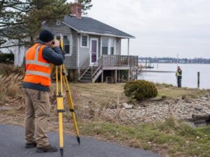
Baltimore sits along tidal water and low ground. Flood risk is real. An Elevation Certificate documents building and ground elevations relative to flood levels. It helps set insurance rates, guide permits, and confirm compliance. Many property owners misunderstand what the certificate does and how it works. Clear answers help you use this document correctly.
Start by Confirming Why the Elevation Certificate Is Being Requested
Different needs require slightly different information. Insurance companies need specific elevations to calculate premiums. Lenders need proof the building sits above certain levels before approving a loan. Planning departments need elevations to issue permits or verify floodplain rules. Property owners need them to understand risk and plan improvements.
Tell the surveyor exactly who will receive the certificate and what they will do with it. They make sure the right elevations are measured and the correct form is used. A certificate prepared for insurance may not have all details needed for a building permit. Clear purpose at the start avoids delays or having to redo the work later.
Identify the Building Information the Surveyor Must Document
The certificate records key elevations. Surveyors measure the ground around the building. They measure the lowest floor including basements. They measure where utilities enter and where mechanical equipment sits. They note openings such as doors and vents that let water flow through. They also record the building’s flood zone and map panel reference.
What gets measured depends on building design and flood rules. A house on a slab needs different measurements than a building with a basement or elevated floor. The surveyor follows standard requirements but also matches details to your specific building. Accurate measurements matter. Even a few inches can change insurance costs or permit approvals by thousands of dollars.
Flood Map Information and Field Elevations Serve Different Purposes
Official Flood Insurance Rate Maps show flood zones and estimated flood heights. They tell you what risk applies generally to the area. They do not tell you the exact elevation of your specific building. That requires on-site measurement. The Elevation Certificate combines both sources. It uses the map’s estimated flood height and compares it against surveyed building elevations.
Lower flood insurance premiums happen when the building sits well above the mapped flood level. But the map alone cannot prove that. Only actual field measurements can. The certificate connects the general map to your specific property. Both parts are needed to understand your true risk and cost.
Renovations Can Make an Older Certificate Worth Reviewing
Building improvements change elevations. Adding fill around the foundation raises ground levels. Finishing a basement may change what counts as the lowest floor. Enclosing a crawlspace or raising mechanical equipment changes key measurements. If you built or improved since your last certificate, the document may no longer be accurate.
An outdated certificate can overstate or understate your risk. That means paying too much for insurance or facing unexpected flood damage. Lenders or insurance companies may reject it entirely. Have a surveyor review the old certificate against current conditions. They may update measurements or confirm the document still works. Small changes can sometimes make a big difference.
Keep the Completed Certificate With the Property Records
An accurate Elevation Certificate stays useful for years. It helps when you sell the property. It speeds up insurance renewals. It guides future renovations or permits. Keep the original and copies in a safe place. Share copies with your insurance agent, lender, and city planning department.
When you sell, buyers will ask about flood risk. Giving them a complete certificate saves time and money during their review. They do not need to pay for a new survey unless conditions change. The document becomes part of your property records just like a deed or survey. Protect it so you and future owners benefit from the work.
Frequently Asked Questions
When does a Baltimore property owner need an Elevation Certificate?
Common reasons include buying flood insurance, getting a mortgage, applying for building permits, or selling property located in a mapped flood zone.
Can an older Elevation Certificate still be used after renovations?
Only if the work did not change ground levels, floor elevations, or equipment placement. Major changes need updated measurements.
What building elevations are measured for the certificate?
Surveyors measure ground level, lowest floor elevation, and mechanical equipment height. They also note openings and flood zone details.
Is an Elevation Certificate the same thing as a floodplain survey?
No. A floodplain survey shows boundaries and setbacks. The Elevation Certificate records specific height measurements for insurance and lending.
Does receiving an Elevation Certificate change a property’s flood-zone designation?
No. The certificate measures elevations. Official flood zone designations come from government maps. Measured elevations may lower insurance rates but do not change the zone itself.
For a free land surveying quote, call us at (410) 883-5300 or send us a message by going here.
Posted in Elevation Certificate
