
Assembling Vacant Parcels Into One Development Site With an ALTA Survey
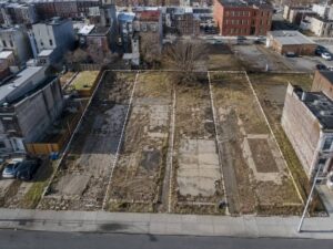
An ALTA survey is the tool that makes a scattered set of vacant lots into a financeable development site. A fragmented city block looks like an opportunity on a map. In the records it’s a mess of separate deeds, some written a century apart, describing lots that may not quite fit together. Before a lender funds the deal or a title company insures it, someone has to prove where every parcel sits and how the pieces combine. That proof is the ALTA survey.
Organizing Deeds and Plats for a Fragmented Block
The work begins with research, and there’s usually a lot of it. A block being assembled might contain a dozen or more separately described parcels. The surveyor collects the deed for each one, along with the original plats, prior surveys and the title commitment listing what affects the property.
Old records describe land inconsistently. Some parcels use lot and block references from a subdivision. Others use metes and bounds written by different surveyors in different decades. A few may reference monuments or structures that vanished long ago. The surveyor sorts these into a coherent picture, tracking which conveyance came first and how the block was pieced together over time.
That organized foundation supports everything after it. Trying to assemble a block without first untangling the records produces a survey full of assumptions, and assumptions are exactly what a lender’s title review is designed to catch.
Resolving Missing Lines and Inconsistent Parcel Dimensions
Independently written descriptions rarely agree at the edges. One deed calls a lot twenty-five feet wide while the plat shows twenty-four and a half. The neighbor’s description may claim part of the same ground, or leave a sliver that belongs to no one. Across a whole block, those small conflicts add up.
The surveyor measures what exists and compares it against every record. Gaps show up as narrow strips that no deed clearly covers. Overlaps show up where two descriptions claim the same ground. Each gets shown on the drawing with the measured and record dimensions side by side, so nothing gets averaged into invisibility.
Rules of seniority guide the analysis. When two parcels overlap, the earlier conveyance generally holds and the later one yields. The surveyor applies those principles, but resolving a gap or a serious conflict in title usually requires a corrective deed, a quitclaim or a legal action. The survey identifies the problem and points toward the fix.
Accounting for Alleys, Rights-of-Way, and Public Reservations
Fragmented blocks often contain public interests that everyone forgot about. An alley may still exist on record even though it’s been paved over or fenced off for decades. Old rights of way, easements and public reservations can sit inside the assembly, quietly limiting what gets built.
Research reveals their status. The surveyor checks whether an alley was ever formally vacated, whether an easement remains active, and whether a public reservation still binds the land. Those answers change the buildable area and sometimes the whole development plan.
Field evidence confirms the record. Crews look for pavement remnants, utility structures and worn paths inside these strips, then map them against the recorded limits. A sewer line running through a supposedly abandoned alley tells the design team something they need to know before they plan a building on top of it.
Showing Remaining Structures and Cross-Lot Improvements
Vacant lots are rarely as empty as they look. Foundations from demolished buildings sit below grade. Old walls, slabs, fences and pavement cross the interior lot lines. Utility lines run through the assembly serving properties that may not even be part of it.
The survey locates and shows all of it. A buried foundation affects where new construction can go and how much demolition the site still needs. A fence crossing an interior line hints at how the block has been occupied. Cross-lot utilities may need to be relocated or granted easements before the development proceeds.
These features matter for both cost and title. A structure crossing a boundary can create a claim that has to be cleared. Improvements that don’t match the record ownership raise questions the title company will want answered before closing.
Delivering One Coordinated Survey for Closing and Redevelopment
The finished product ties the whole assembly together on one drawing. It shows the outer perimeter, the interior lot lines that still exist on record, the public strips, the encroachments and every easement the research and fieldwork uncovered. A combined legal description usually accompanies it.
That single document serves many parties at once. The title company reviews it against the commitment and decides what exceptions it can remove. The lender relies on it to understand exactly what secures the loan. Planners use it for the replat that will create the new development parcels, and designers use it to lay out the project on ground they can trust.
Delivering everything coordinated is the point. A developer assembling fifteen parcels can’t work from fifteen separate surveys that don’t quite align. One ALTA survey, tied together and certified, turns the fragmented block into a site the whole team can build on.
Frequently Asked Questions
Can one ALTA survey cover an entire group of vacant parcels?
Yes. A single ALTA survey can research, measure and depict a group of adjoining parcels as one coordinated project, showing both the combined perimeter and the interior lines. Each parcel still receives its own boundary determination, and the survey can be certified to the buyer, lender and title company for the whole assembly.
What happens when the lots have different owners?
The survey maps the parcels regardless of who owns them, which is often exactly what a buyer needs while negotiating to acquire them. The drawing shows the ownership pattern and the boundaries, while the actual purchase and combination of the parcels happens through the deeds and closing. Different ownership doesn’t prevent the survey.
Will the survey show foundations from previously demolished buildings?
It shows the foundations and other structures that crews can find in the field, including remnants at or near the surface. Deeply buried features may not be detectable, so the survey reports what the evidence reveals. Locating known foundations matters because they affect both construction planning and title.
For a free land surveying quote, call us at (410) 883-5300 or send us a message by going here.
Posted in ALTA Survey
